Summary
The Andean region is located in one of the most seismically active regions of the world, where the responsible process is the subduction of the Nazca plate underneath the South American plate, in an exceptional convergent environment. The Central Andes portion presents the highest seismicity level in western South America and includes the Peru-Chile seismic border region(see Fig. 1), that has been shaken by three earthquakes with MW close to 9.0, among many other smaller magnitude earthquakes that provoked serious damage in several places of the Central Andes. Those large events occurred near the Arica elbow in 1604, 1868 and 1877. They destroyed most of the populated areas in Northern Chile and Southern Peru located a few hundred kilometres from the epicentres, and provoked tsunamis with waves up to 20 m high that reached the western margins of the Pacific ocean.
Several authors, among them Delouis et al. (1996), Spence et al. (1998), believe that recent large earthquakes that have occurred in the Central Andes between 1994 and 1996, are premonitory events of a large catastrophic earthquake that may occur in the Peru-Chile border region in the next few years. Zamudio, (1998) and Zamudio & Berrocal (1999), based on seismicity studies with hypocentres relocated from teleseismic data by Engdahl et al. (1998), indicate the probable occurrence of a maximum potential earthquake in the Peru-Chile border region during the next few decades.
Due to its large seismic hazard potential, the Peru-Chile border region was appointed by UNESCO in 1984, as a probable Experimental Site for Earthquake Prediction Research, and organized through CERESIS a Mission to study the feasibility of this site. The corresponding report was prepared by Cabré et al (1984). Since then, several important seismological and tectonic deformation projects have been carried out mainly in northern Chile and its border region with Bolivia with the participation of European and American geophysicists in collaboration with Chilean and Bolivian colleagues.
Among those projects are the PISCO and CALAMA projects that involved the installation of a regional network of seismographic stations around Antofagasta; the BANJO and SEDA projects, two normal linear arrays of broadband seismographs installed in northern Chile and south-western Bolivia for structure and anisotropy studies; the LITHOSCOPE short period digital network for velocity structure and tomography studies; the array of GPS points for tectonic deformation control at the latitude of Antofagasta, operated by the Geophysical Department of IPG-Paris group; and the CINCA and other experiments, such as the PISCO network and others for passive and active seismological studies, as well as for wide angle deep refraction onshore and deep reflection offshore lines, belonging to the “Deformation Processes in the Central Andes” project. This project was established and funded in 1993 by German institutions and by the German Research Society (DGF). More recently the Universities of Chile and of Tarapaca have installed, with the collaboration of ORSTOM, a network of 14 short period stations in the extreme north of this country, known as the Arica Network.
Few experiments of this kind were executed during the last decades on the Peruvian side of the Peru-Chile border region. The most important experiments were carried out in the 1970-80’s through the installation of temporary regional networks by using Carnegie short period seismographs, first in southern Peru and later on in central Peru. More recently, the installation of a regional network of broadband stations, by the Instituto Geofísico del Peru, with six stations installed in the southern Peru region.
The results of those projects and determinations using regional earthquakes with teleseismic data, provided good knowledge of the structure of the Wadati Benioff Zone (WBZ) for some segments in northern Chile and southern Peru. Those results show a complex tectonic setting beneath the Central Andes, where several processes associated to the subduction of the Nazca plate may be acting to accumulate and to release the tectonic energy in that region. To obtain a complete view of the seismotectonic structure beneath the Central Andes to determine the seismic sources acting in that region and to establish the seismicity pattern in each source and between those sources, it would be necessary to observe simultaneously all the segments in the Central Andes by using modern seismographic homogeneous equipment with emphasis in the region that surrounds the Arica elbow, where the three earthquakes with MW close to 9.0 have occurred.
We present in this document a research proposal to carry out comprehensive seismological and tectonic deformation studies in the region between 13°S – 26°S and 60°W – 80°W, to determine the seismotectonic structure and the seismicity regime in this region in order to create conditions for future earthquake prediction studies in the Central Andes, mainly in the Peru-Chile seismic border region. The proposed study region comprises: the southern region of Peru, the northern region of Chile, the central and western regions of Bolivia and the north-western region of Argentina.
The seismological studies should be performed through the installation of the Seismological Network of the Central Andes (SENECA). This network shall be composed with about 90 high dynamic range broadband stations with digital recorders, to be borrowed from the PASSCAL and/or GEOFON programs, and by similar broadband permanent or temporary stations installed in the region of study, that might be operating during this project interval, to complement the number of stations needed to achieve the objectives of this project. Final characteristics and settings of the seismographic broad band equipment necessary to accomplish the objectives of this project shall be determined with the advice from the staff of the Instrument Centres of those programs. Data of short period digital stations that may be operating in the region during the project interval shall also be utilised in some studies, if available.
The attached map (see fig. 2) is a sketch of the SENECA network, which spans the continental portion of the WBZ horizontal surface projection in the study region, differentiating the three following monitoring stages of the project:
First Stage: the first two years, 90 stations
Second Stage: the two following years, 58 stations
Third Stage: permanent monitoring, 24 stations
The borrowed equipment shall be used during the first two stages. For the third stage, all permanent broadband stations installed in the Central Andes should be considered. These will be complemented with similar stations to be acquired for the project and, if possible, all of them linked to Data Processing Centre(s). Presently (middle 1999), there are 10 broadband stations operating in the region, at least three of them working on a permanent or semi-permanent basis.
For the routine analysis, the use of the software package GIANT (Graphical Interactive Aftershock Network) developed by Rietbrock (1998), is recommended. This package makes it possible to handle data of a large-scale seismological experiment, like that proposed in this project, even if the data is not recorded in the same format. It determines the hypocentral parameters with a 1D-velocity model and calculates the focal mechanism with P-wave polarities or with polarities of P, SV and SH waves. It is also possible with GIANT to use amplitude ratio information for further constraints of focal mechanism and also to perform simultaneous estimation of hypocentral parameters and 3-D velocity structure. Other inversion and tomographic methods, some of them mentioned in this proposal, can be used to determine the seismotectonic structure beneath the Central Andes. In this context, the use of teleseismic data recorded at SENECA will allow the use of methods like the receiver function method and anisotropy of the mantle studies to define the structure beneath the study region.
The seismicity patterns in the Central Andes should be established mainly during the first two-year stage of the project, by using data of regional earthquakes with a threshold of about mb 2.5. Seismicity parameters should be found for each seismic source to be defined during the structure studies and shall be confirmed or modified during the second two-year stage.
During the permanent stage, those seismicity patterns shall be continuously checked as well as the focal mechanism behaviour in each seismic source shall be controlled, looking for changes that precede larger magnitude earthquakes in those sources. The seismological studies shall be complemented with high precision GPS tectonic deformation measurements performed in already established nets or in new nets to be installed as necessary. In this case some permanent GPS stations with telemetry link with the Data Processing Centre(s) would be necessary.
This project will permit the definition of the structural model beneath the Central Andes as nearly as possible to the real model. It will also help to clarify some existent controversies and to understand some seismotectonic peculiarities already found in this region. The seismicity patterns to be established during this project and the permanent tectonic deformation control in this region, will certainly be useful for future earthquake prediction studies in the Central Andes, especially in the Peru-Chile border region.
Besides the scientific objectives mentioned above, the project has complementary objectives that concern the regional institutions participating in this project, such as:
a) The installation of a permanent seismographic network with high dynamic range triaxial broadband digital stations and of high resolution GPS stations, linked by telemetry to one or more Data Processing Centres for near real time data processing;
b) The conditioning of participating institutions of the region, to use modern methods to process digital seismic data, with proper computing equipment and software, and the involvement of their staff in resulting scientific research;
c) The opportunity to work with distinguished scientists from outside of the CERESIS region;
d) The training of specialized personnel, from field technicians to graduate scientists;
e) The production of a significant number of M.Sc. and Ph.D. thesis, scientific papers and participation in international meetings, of students and members of the participating institutions of the Central Andes.
This proposal is being prepared by CERESIS, with the participation of the following South American institutions:
Departamento de Geofísica, Universidad de Chile, Santiago, Chile
Instituto Nacional de Prevención Sísmica – INPRES, San Juan, Argentina
Instituto Geofísico del Perú, Lima, Perú
Instituto Geofísico, Universidad de San Agustín, Arequipa, Perú
Observatorio San Calixto, La Paz, Bolivia
Instituto Astronômico e Geofísico, Universidade de São Paulo, São Paulo, Brasil.
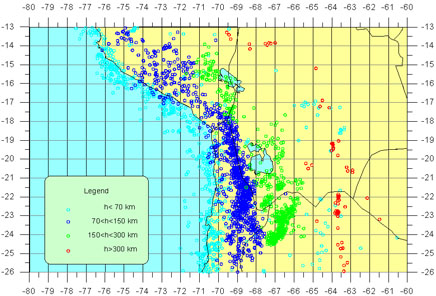 Fig. 1
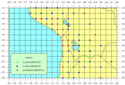 Fig 2
Fig 2


